Unlike traditional radio frequency systems, lasercomm offers dramatically higher bandwidth and enhanced security, making it a key enabler for next-generation satellite missions and data-hungry applications. However, this leap in capability comes with new vulnerabilities—particularly the sensitivity of optical signals to atmospheric conditions. Even minor disruptions, such as cloud cover or atmospheric turbulence, can severely degrade or interrupt the laser link between space assets and ground stations, jeopardizing successful transmission and data integrity.
The Critical Role of Cloud Forecasts: The role of All-sky Imagers
Weather is a key factor for establishing a successful free-space optical transmission link through the atmosphere. A loss in signal intensity or attenuation,
can be caused by several weather conditions, such as heavy rain or fog, and weather is the main cause of attenuation overall. By integrating advanced meteorological data into operational workflows, teams can anticipate potential disruptions, dynamically schedule downlinks, and select optimal ground station sites. To ensure uninterrupted space-to-ground communication, accurate cloud forecasts for the upcoming minutes have become an important tool for mission planners and ground station operators.
About 70% of the Earth’s surface is covered by clouds, which are a main part of the Earth’s atmosphere. Free space optical communication is affected by clouds, which are basically water deposited above Earth’s surface. The most-used wavelength (1550nm) favours a good transmittance through the atmosphere. However, the occurrence of clouds directly impacts the laser communication signal passing through the atmosphere. Cloud Optical depth (COD) is the key parameter to assess
the effect of clouds on free space optical communications from satellites to the ground or from/to aircraft. COD is proportional to the cloud’s liquid water density (kg/m) and allows to estimate the scattering and absorption properties based on the cloud thickness and particle sizes.
The typical radiative properties of the common types of clouds can be evaluated by different means: Global annual mean data sets are available from different providers, but offer only statistical evaluations by region and cloud type. Satellite imagery can also be used to obtain cloud data in real time and is especially useful to
forecast low elevation clouds which might not be on the sky imager’s horizon because they are still too far away. However, the most accurate short-term forecasts of cloud motion and cloud properties for one location can be obtained from the ground using a sky imager in the infrared spectrum. Reuniwatt’s infrared imager Sky InSight™ provides continuous, high-resolution cloud observations and forecasts both day and night. For satellite-to-ground line-of-sight forecasting, it can be beneficial to combine the forecasts from an all-sky imager with forecasts derived from satellite imagery, because the field of view of the locally installed instrument is limited (depending on the presence of clouds at low altitude, as well as the surrounding landscape).
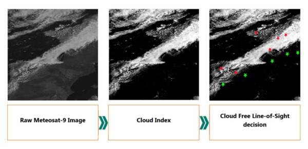
Figure 1: Satellite image processing for Free Line-of-Sight Decision. Red stars indicate a potential blockage of the signal by clouds, and green
stars indicate a free line-of-sight.
Connect with us to learn more about cloud cover forecasts for OGS networks
Reuniwatt is actively involved in several Free-Space Optical Communication projects and providing cloud forecasts for Optical Ground Station networks. We have already organized two webinars dedicated to the topic, which our readers can watch on demand:
-
Wireless Laser Communication: Don’t let clouds get in the way of success!
In this webinar Reuniwatt, Airbus, and Systematic Paris-Region discuss how the combination of FSOC and weather forecasting technology is poised to change the communications market as we know it! Watch this webinar to learn more about precision cloud forecasting.
-
No Clouds on the Horizon: The Future Looks Bright for FSOC
In this webinar with Reuniwatt, Mynaric, and Fraunhofer IOSB discuss the current challenges of FSOC. Watch this webinar to learn more about the latest advancements in free-space optical communications, dense multiwavelength division multiplexing (DWDM), and ensuring reliable, robust optical communication past the clouds and near urban centers.
Reuniwatt’s all-sky imagers and expertise stand ready to support enhanced contrail observation, identification, and forecasting efforts. We already have a network of numerous all-sky imagers in Europe, and provide DaaS. Contact us to learn how our solutions can support your goals.

